


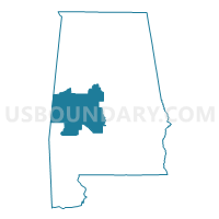
Dallas, Bibb, Marengo, Hale, Sumter, Perry & Greene Counties PUMA, Alabama
About
Outline

Summary
| Unique Area Identifier | 192099 |
| Name | Dallas, Bibb, Marengo, Hale, Sumter, Perry & Greene Counties PUMA |
| State | Alabama |
| Area (square miles) | 5,556.29 |
| Land Area (square miles) | 5,492.76 |
| Water Area (square miles) | 63.53 |
| % of Land Area | 98.86 |
| % of Water Area | 1.14 |
| Latitude of the Internal Point | 32.58945690 |
| Longtitude of the Internal Point | -87.59664390 |
Maps

Graphs
Select a template below for downloading or customizing gragh for Dallas, Bibb, Marengo, Hale, Sumter, Perry & Greene Counties PUMA, Alabama


Neighbors
Neighoring Public Use Microdata Area (by Name) Neighboring Public Use Microdata Area on the Map
- Chilton, Tallapoosa, Chambers & Coosa Counties PUMA, AL
- East Central Region--Lauderdale, Newton & Clarke Counties--Meridian City PUMA, MS
- East Central Region--Neshoba, Scott, Leake, Jasper, Smith & Kemper Counties PUMA, MS
- Elmore, Autauga, Montgomery (Outer) & Lowndes Counties PUMA, AL
- Golden Triangle Region--Starkville, Columbus & West Point Cities PUMA, MS
- Jefferson County (West)--Bessemer, Hueytown & Pleasant Grove Cities PUMA, AL
- Shelby County PUMA, AL
- Southwest Alabama PUMA, AL
- Tuscaloosa (Outer) & Pickens Counties--Northport City (North & West) PUMA, AL
Top 10 Neighboring County (by Population) Neighboring County on the Map
- Jefferson County, AL (658,466)
- Shelby County, AL (195,085)
- Tuscaloosa County, AL (194,656)
- Lauderdale County, MS (80,261)
- Autauga County, AL (54,571)
- Dallas County, AL (43,820)
- Chilton County, AL (43,643)
- Clarke County, AL (25,833)
- Bibb County, AL (22,915)
- Marengo County, AL (21,027)
Top 10 Neighboring County Subdivision (by Population) Neighboring County Subdivision on the Map
- Alabaster-Helena CCD, Shelby County, AL (118,831)
- Selma CCD, Dallas County, AL (32,439)
- Greenwood CCD, Jefferson County, AL (22,289)
- District 5, Lauderdale County, MS (16,062)
- District 2, Lauderdale County, MS (15,435)
- Jemison CCD, Chilton County, AL (14,242)
- Centreville-Brent CCD, Bibb County, AL (12,937)
- Montevallo CCD, Shelby County, AL (10,134)
- Abernant CCD, Tuscaloosa County, AL (9,955)
- Demopolis CCD, Marengo County, AL (9,554)
Top 10 Neighboring Place (by Population) Neighboring Place on the Map
- Selma city, AL (20,756)
- Demopolis city, AL (7,483)
- Brent city, AL (4,947)
- Valley Grande city, AL (4,020)
- Marion city, AL (3,686)
- Livingston city, AL (3,485)
- Eutaw town, AL (2,934)
- Centreville city, AL (2,778)
- Selmont-West Selmont CDP, AL (2,671)
- York city, AL (2,538)
Top 10 Neighboring Unified School District (by Population) Neighboring Unified School District on the Map
- Jefferson County School District, AL (230,679)
- Shelby County School District, AL (170,473)
- Tuscaloosa County School District, AL (105,218)
- Autauga County School District, AL (54,571)
- Chilton County School District, AL (43,643)
- Lauderdale County School District, MS (39,113)
- Dallas County School District, AL (23,064)
- Bibb County School District, AL (22,915)
- Selma City School District, AL (20,756)
- Clarke County School District, AL (19,941)
Top 10 Neighboring State Legislative District Lower Chamber (by Population) Neighboring State Legislative District Lower Chamber on the Map
- State House District 62, AL (55,022)
- State House District 49, AL (52,014)
- State House District 15, AL (48,965)
- State House District 42, AL (48,338)
- State House District 61, AL (41,422)
- State House District 72, AL (39,414)
- State House District 65, AL (38,681)
- State House District 71, AL (38,094)
- State House District 67, AL (37,878)
- State House District 69, AL (37,572)
Top 10 Neighboring State Legislative District Upper Chamber (by Population) Neighboring State Legislative District Upper Chamber on the Map
- State Senate District 14, AL (168,669)
- State Senate District 21, AL (140,682)
- State Senate District 22, AL (137,373)
- State Senate District 24, AL (118,832)
- State Senate District 23, AL (111,939)
- State Senate District 33, MS (56,120)
- State Senate District 32, MS (49,900)
Top 10 Neighboring 111th Congressional District (by Population) Neighboring 111th Congressional District on the Map
- Congressional District 3, MS (756,924)
- Congressional District 6, AL (754,482)
- Congressional District 1, AL (687,841)
- Congressional District 2, AL (673,877)
- Congressional District 4, AL (660,162)
- Congressional District 7, AL (603,352)
Top 10 Neighboring Census Tract (by Population) Neighboring Census Tract on the Map
- Census Tract 142.03, Jefferson County, AL (12,502)
- Census Tract 106.02, Tuscaloosa County, AL (9,955)
- Census Tract 604.02, Chilton County, AL (8,776)
- Census Tract 100.04, Bibb County, AL (8,767)
- Census Tract 107.02, Tuscaloosa County, AL (7,684)
- Census Tract 106, Lauderdale County, MS (7,630)
- Census Tract 9561, Dallas County, AL (6,753)
- Census Tract 101.03, Tuscaloosa County, AL (6,727)
- Census Tract 107.01, Tuscaloosa County, AL (6,568)
- Census Tract 113, Sumter County, AL (6,251)
Top 10 Neighboring 5-Digit ZIP Code Tabulation Area (by Population) Neighboring 5-Digit ZIP Code Tabulation Area on the Map
- 39301, MS (27,449)
- 36701, AL (24,268)
- 35022, AL (18,888)
- 35111, AL (16,140)
- 35080, AL (15,881)
- 35115, AL (14,118)
- 36703, AL (13,643)
- 35453, AL (11,127)
- 36732, AL (8,395)
- 36784, AL (7,754)